 vesseltracker.com
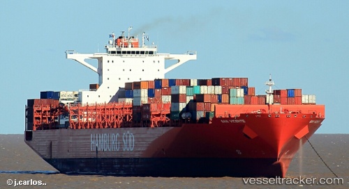
 San Vicente
Current Status
Where is the vessel?
San Vicente is currently in 47 nm E of Queen Charlotte, based on AIS data received less than 1h ago.
Latest AIS update:
Current position: 53.29044° N, 130.77133° W (47 nm E of Queen Charlotte)
Average speed (last 7 days): Loading…
Average speed (last 30 days): Loading…
Vessel profile: San Vicente is a Container Ship with dimensions 300m x 48m.
This page combines live AIS, route history, probable destination signals, nearby traffic, and port activity for practical vessel monitoring.
The current position of vessel San Vicente is 53.29044 lat / -130.77133 lng. Updated: 2026-05-16 11:59:34 UTCNearest reference points:
- Near Watson Island
- Near Prince Rupert
- Near Queen Charlotte
Currently sailing under the flag of Singapore ![]()
Details:
Live Vessel San Vicente Analytics (details, animations, etc.)
Recent AIS points (UTC):
2026-05-16 07:54:03 UTC · 53.90361, -130.98135 · SOG 8.8 kn · COG 168°2026-05-16 09:48:17 UTC · 53.61827, -130.89938 · SOG 9.8 kn · COG 168°
2026-05-16 10:04:34 UTC · 53.57539, -130.88269 · SOG 9.8 kn · COG 167°
2026-05-16 11:59:34 UTC · 53.29044, -130.77133 · SOG 9.2 kn · COG 172°