 vesseltracker.com
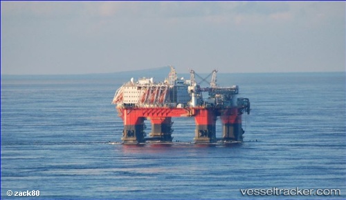
 Safe Zephyrus
Current Status
Where is the vessel?
Safe Zephyrus is currently in 54 nm N of Cidade de Angra dos Reis FPSO, based on AIS data received less than 1h ago.
Latest AIS update:
Current position: 24.68793° S, 42.51112° W (54 nm N of Cidade de Angra dos Reis FPSO)
Average speed (last 7 days): Loading…
Average speed (last 30 days): Loading…
Vessel profile: Safe Zephyrus is a Service Ship with dimensions 104m x 91m.
This page combines live AIS, route history, probable destination signals, nearby traffic, and port activity for practical vessel monitoring.
The current position of vessel Safe Zephyrus is -24.68793 lat / -42.51112 lng. Updated: 2026-05-15 12:00:22 UTCNearest reference points:
- 69 nm NE of Cidade de Angra dos Reis FPSO
- 34 nm S of Cidade de Angra dos Reis FPSO
- 49 nm S of SEPETIBA
Currently sailing under the flag of Singapore ![]()
Details:
Live Vessel Safe Zephyrus Analytics (details, animations, etc.)
Recent AIS points (UTC):
2026-05-15 07:54:01 UTC · -24.68791, -42.51113 · SOG 0.1 kn · COG 155°2026-05-15 09:40:25 UTC · -24.68795, -42.51114 · SOG 0.4 kn · COG 150°
2026-05-15 10:44:45 UTC · -24.68794, -42.51112 · SOG 0.4 kn · COG 149°
2026-05-15 12:00:22 UTC · -24.68793, -42.51112 · SOG 0.1 kn · COG 149°