.
Vessel photo of ENI (IMO 9258674) vesseltracker.com

KM flag ENI

Vessel type: Oil Products Tanker | IMO: 9258674 | MMSI: MMSI: 616999235
Call sign: D6HE6 | Dimensions: 182 m x 32 m
Current Status

Where is the vessel?

ENI is currently in 262 nm W of Iba, based on AIS data received about 180d ago.

Latest AIS update:

Current position: 15.40688° N, 115.44077° E (262 nm W of Iba)

Average speed (last 7 days): Loading…

Average speed (last 30 days): Loading…

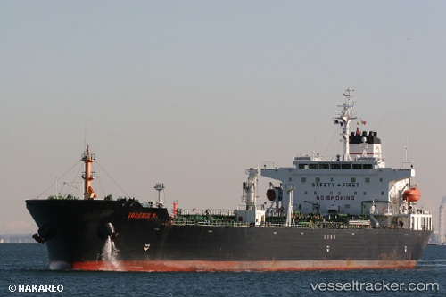
Vessel profile: ENI is a Oil Products Tanker with dimensions 182m x 32m.

This page combines live AIS, route history, probable destination signals, nearby traffic, and port activity for practical vessel monitoring.

The current position of vessel ENI is 15.40688 lat / 115.44077 lng. Updated: 2025-11-17 05:07:06 UTC
Nearest reference points:
  • 222 nm W of Iba
  • 282 nm E of Tan Cang Qui Nhon
  • 232 nm E of Tan Cang Qui Nhon

Currently sailing under the flag of Comoros KM flag

ENI built in 2003 year

Deadweight:
46349 t

Details:

Live Vessel ENI Analytics (details, animations, etc.)


Recent AIS points (UTC):
2025-11-17 05:07:06 UTC · 15.40688, 115.44077 · SOG 10.2 kn · COG 254°

Track of the vessel in the last 60 days


UTC: --
Start: -- Track timeline (UTC) End: --
Encountered: --


Link to the map:


Find another ship

ENI (616999235) last ports (portcalls and passsages)

RAS SHUKHEIR | 2024-12-10 04:52:25
AL ADABIYAH | 2024-12-09 18:34:23
SUEZ PORT | 2024-12-09 17:12:53
SUEZ CANAL | 2024-12-09 14:49:22
ISMAILIA | 2024-12-09 13:01:03
Port Said | 2024-12-09 07:28:01
Bandar-E Mah Shahr | 2024-02-19 08:07:37
Fujairah | 2024-02-11 16:56:44
Port Sudan | 2023-11-20 04:50:38
Fujairah | 2023-11-11 11:25:27
Fujairah | 2023-11-07 11:13:23
Fujairah | 2023-11-03 11:01:08
Hamriyah | 2023-10-28 20:12:05
Hamriyah | 2023-10-24 19:47:08
Hamriyah | 2023-10-11 19:27:12
Jebel Ali | 2023-05-26 19:28:04
Berbera | 2023-03-10 14:44:32
Ra’S Shukhayr | 2023-03-04 05:34:13
Ayn Sukhnah | 2023-03-03 20:17:18
Bur Ibrahim | 2023-03-03 18:03:31
Ambarli | 2023-02-16 08:54:48