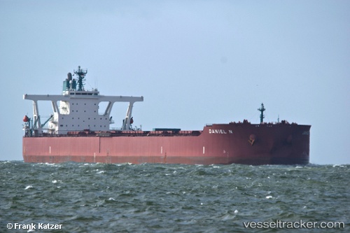
.
Vessel photo of Daniel N (IMO 9398175) vesseltracker.com

LR flag Daniel N

Vessel type: Ore Carrier | IMO: 9398175 | MMSI: MMSI: 636014329
Call sign: A8TC9 | Dimensions: 327 m x 55 m
Current Status

Where is the vessel?

Daniel N is currently in Near Tubarão Pt./Vitória, based on AIS data received less than 1h ago.

Latest AIS update:

Current position: 20.40187° S, 40.19656° W (Near Tubarão Pt./Vitória)

Average speed (last 7 days): Loading…

Average speed (last 30 days): Loading…

Vessel profile: Daniel N is a Ore Carrier with dimensions 327m x 55m.

This page combines live AIS, route history, probable destination signals, nearby traffic, and port activity for practical vessel monitoring.

The current position of vessel Daniel N is -20.40187 lat / -40.19656 lng. Updated: 2026-04-15 04:17:13 UTC
Nearest reference points:
  • Near Tubarão Pt./Vitória
  • Near JARDIM CAMBURI
  • Near BAIA DE VITORIA

Currently sailing under the flag of Liberia LR flag

Daniel N built in 2011 year

Deadweight:
297359 t

Details:

Live Vessel Daniel N Analytics (details, animations, etc.)


Recent AIS points (UTC):
2026-04-14 19:26:08 UTC · -20.40079, -40.19765 · SOG 0.1 kn · COG 83°
2026-04-14 21:59:08 UTC · -20.40160, -40.19719 · SOG 0.2 kn · COG 71°
2026-04-15 00:05:18 UTC · -20.40199, -40.19696 · SOG 0.3 kn · COG 44°
2026-04-15 04:17:13 UTC · -20.40187, -40.19656 · SOG 0.5 kn · COG 48°

Track of the vessel in the last 60 days


UTC: --
Start: -- Track timeline (UTC) End: --
Encountered: --


Link to the map:


Find another ship

Daniel_N (636014329) last ports (portcalls and passsages)

JURONG ISLAND | 2025-08-23 23:03:19
PULAU SAMBU | 2025-08-23 21:38:06
BATU AMPAR | 2025-08-23 20:39:49
TANAH MERAH | 2025-08-22 19:15:17
PENGERANG | 2025-08-22 17:57:59
SURALAYA | 2025-07-14 01:40:56
JURONG ISLAND | 2025-04-26 10:52:18
PULAU SAMBU | 2025-04-26 09:49:41
Singapore | 2025-04-25 08:48:02
TANAH MERAH | 2025-04-25 06:21:07
Dagu Bar | 2025-04-15 01:26:54
Dagu Bar | 2025-04-08 17:06:31
Taku Bar | 2025-04-08 15:16:34
PENGERANG | 2025-03-23 14:07:54
BATU AMPAR | 2025-03-23 11:53:57
PULAU SAMBU | 2025-03-23 11:17:49
BUKOM ISLAND | 2025-03-23 10:15:43
PULAU SAMBU | 2024-12-31 10:34:46
BATU AMPAR | 2024-12-31 09:48:02
TANAH MERAH | 2024-12-27 11:47:13
PENGERANG | 2024-12-27 09:28:02
Rizhao | 2024-12-16 08:40:33
Rizhao | 2024-12-12 08:21:16
PENGERANG | 2024-11-28 15:36:12
TANAH MERAH | 2024-11-28 14:28:27
PULAU SAMBU | 2024-11-28 13:26:31
BUKOM ISLAND | 2024-11-28 12:28:24
Singapore | 2024-07-26 22:43:14
Singapore | 2024-04-28 17:49:03
Sambu | 2024-04-05 03:34:53
Ponta da Madeira | 2024-02-22 15:51:42
Singapore | 2023-12-13 05:29:51
Sambu | 2023-12-13 05:12:47
Tubarao | 2023-11-03 11:12:19
Singapore | 2023-09-28 07:38:48
Sambu | 2023-09-11 16:13:42
Ponta da Madeira | 2023-07-27 23:19:34
Sambu | 2023-06-21 18:51:57
Singapore | 2023-04-19 04:43:12
Sao Luiz | 2023-03-03 08:51:55
Singapore | 2023-01-10 08:33:03
Saldanha Bay | 2022-11-04 05:39:43
Singapore | 2022-10-11 16:43:37
Dagu Bar | 2022-09-17 01:11:24
Port Headland | 2022-08-24 04:54:16
Selat Lombok | 2022-07-17 08:00:27
Port Headland | 2022-07-12 05:04:13
Port Headland | 2022-05-23 04:27:33
Port Headland | 2022-04-10 09:52:51
Selat Lombok | 2022-02-25 21:03:42
Port Headland | 2022-02-20 15:10:33
Selat Lombok | 2022-01-09 20:29:19
Port Headland | 2022-01-05 08:15:28
Port Hedland | 2022-01-05 08:10:48
Selat Lombok | 2021-12-01 12:00:27