 vesseltracker.com
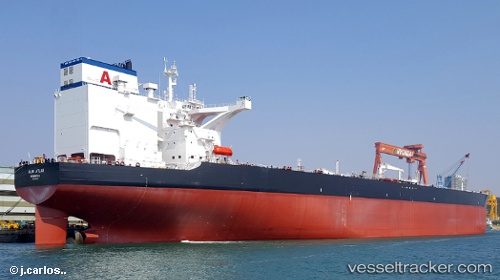
Almi Atlas
Current StatusWhere is the vessel?
Almi Atlas is currently in 35 nm SE of Espírito Santo FPSO, based on AIS data received about 1h ago.
Latest AIS update:
Current position: 21.62983° S, 39.31954° W (35 nm SE of Espírito Santo FPSO)
Average speed (last 7 days): Loading…
Average speed (last 30 days): Loading…
Vessel profile: Almi Atlas is a Crude Oil Tanker with dimensions 60m x 336m.
This page combines live AIS, route history, probable destination signals, nearby traffic, and port activity for practical vessel monitoring.
The current position of vessel Almi Atlas is -21.62983 lat / -39.31954 lng. Updated: 2026-04-24 11:48:11 UTCNearest reference points:
- 68 nm SE of Espírito Santo FPSO
- Near Capixaba FPSO
- 66 nm NE of Espírito Santo FPSO
Details:
Live Vessel Almi Atlas Analytics (details, animations, etc.)
Recent AIS points (UTC):
2026-04-24 08:13:39 UTC · -21.91670, -38.39627 · SOG 15.2 kn · COG 289°2026-04-24 10:15:53 UTC · -21.75285, -38.92656 · SOG 15.2 kn · COG 287°
2026-04-24 10:43:16 UTC · -21.71791, -39.04463 · SOG 15.1 kn · COG 287°
2026-04-24 11:48:11 UTC · -21.62983, -39.31954 · SOG 14.8 kn · COG 289°