 vesseltracker.com
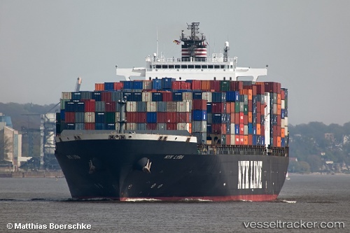
 MYNY
MYNY
Current Status
Where is the vessel?
MYNY is currently in Open sea, approx. 474 nm off the nearest listed port, based on AIS data received about 1h ago.
Latest AIS update:
Current position: 2.99209° N, 65.79644° E (Open sea, approx. 474 nm off the nearest listed port)
Average speed (last 7 days): Loading…
Average speed (last 30 days): Loading…
Vessel profile: MYNY is a Container Ship with dimensions 299m x 40m.
This page combines live AIS, route history, probable destination signals, nearby traffic, and port activity for practical vessel monitoring.
The current position of vessel MYNY is 2.99209 lat / 65.79644 lng. Updated: 2026-04-27 20:00:44 UTCNearest reference points:
- Open sea, approx. 474 nm off the nearest listed port
- Open sea, approx. 479 nm off the nearest listed port
- Open sea, approx. 476 nm off the nearest listed port
Currently sailing under the flag of Liberia ![]()
MYNY built in 2002 year
Deadweight:
78231 tDetails:
Live Vessel MYNY Analytics (details, animations, etc.)
Recent AIS points (UTC):
2026-04-27 16:21:42 UTC · 3.23999, 66.82442 · SOG 17.2 kn · COG 256°2026-04-27 17:16:00 UTC · 3.17914, 66.57256 · SOG 17.2 kn · COG 256°
2026-04-27 19:04:02 UTC · 3.05189, 66.06182 · SOG 17.1 kn · COG 256°
2026-04-27 20:00:44 UTC · 2.99209, 65.79644 · SOG 17.3 kn · COG 255°