 vesseltracker.com
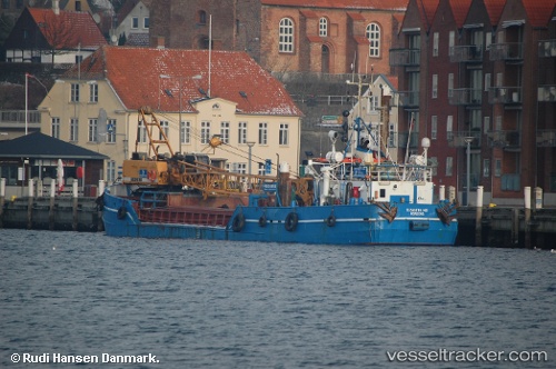
 Elisabeth Hoej
Current Status
Where is the vessel?
Elisabeth Hoej is currently in Near Hov, based on AIS data received less than 1h ago.
Latest AIS update:
Current position: 55.91160° N, 10.25550° E (Near Hov)
Average speed (last 7 days): Loading…
Average speed (last 30 days): Loading…
Vessel profile: Elisabeth Hoej is a Hopper Dredger with dimensions 36m x 8m.
This page combines live AIS, route history, probable destination signals, nearby traffic, and port activity for practical vessel monitoring.
The current position of vessel Elisabeth Hoej is 55.9116 lat / 10.2555 lng. Updated: 2026-05-14 20:04:45 UTCNearest reference points:
- Near Horsens
- Near Randers
- Near Glesborg
Currently sailing under the flag of Denmark ![]()
Elisabeth Hoej built in 1969 year
Deadweight:
226 tDetails:
Live Vessel Elisabeth Hoej Analytics (details, animations, etc.)
Recent AIS points (UTC):
2026-05-14 16:17:55 UTC · 55.91000, 10.25720 · SOG 0 kn · COG 235°2026-05-14 17:25:55 UTC · 55.91160, 10.25550 · SOG 0 kn · COG 247°
2026-05-14 19:45:15 UTC · 55.91160, 10.25550 · SOG 0 kn · COG 248°
2026-05-14 20:04:45 UTC · 55.91160, 10.25550 · SOG 0 kn · COG 248°