 vesseltracker.com
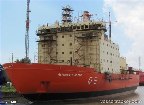
 ALMIRANTE IRIZAR
Current Status
Where is the vessel?
ALMIRANTE IRIZAR is currently in Near Puerto Madero, based on AIS data received about 1h ago.
Latest AIS update:
Current position: 34.59366° S, 58.36556° W (Near Puerto Madero)
Average speed (last 7 days): Loading…
Average speed (last 30 days): Loading…
Vessel profile: ALMIRANTE IRIZAR is a Icebreaker with dimensions 119m x 25m.
This page combines live AIS, route history, probable destination signals, nearby traffic, and port activity for practical vessel monitoring.
The current position of vessel ALMIRANTE IRIZAR is -34.59366 lat / -58.36556 lng. Updated: 2026-05-15 17:20:50 UTCNearest reference points:
- Near Avellaneda
- Near Dock Sur
- Near JUAN LACAZE
Currently sailing under the flag of Argentina ![]()
ALMIRANTE IRIZAR built in 1978 year
Deadweight:
4600 tDetails:
Live Vessel ALMIRANTE IRIZAR Analytics (details, animations, etc.)
Recent AIS points (UTC):
2026-05-15 14:17:58 UTC · -34.59365, -58.36555 · SOG 0 kn · COG -1°2026-05-15 16:26:58 UTC · -34.59365, -58.36555 · SOG 0 kn · COG -1°
2026-05-15 16:47:51 UTC · -34.59367, -58.36556 · SOG 0 kn · COG -1°
2026-05-15 17:20:50 UTC · -34.59366, -58.36556 · SOG 0 kn · COG -1°