 vesseltracker.com
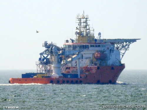
 NORMAND VALIANT
Current Status
Where is the vessel?
NORMAND VALIANT is currently in 16 nm NE of Fluminense FPSO, based on AIS data received less than 1h ago.
Latest AIS update:
Current position: 22.53167° S, 40.16333° W (16 nm NE of Fluminense FPSO)
Average speed (last 7 days): Loading…
Average speed (last 30 days): Loading…
Vessel profile: NORMAND VALIANT is a Offshore Supply Ship with dimensions 20m x 76m.
This page combines live AIS, route history, probable destination signals, nearby traffic, and port activity for practical vessel monitoring.
The current position of vessel NORMAND VALIANT is -22.53167 lat / -40.16333 lng. Updated: 2026-04-28 21:41:18 UTCNearest reference points:
- Near Fluminense FPSO
- Near PORTO DO ACU
- 24 nm SE of Carapebus
Currently sailing under the flag of Brazil ![]()
NORMAND VALIANT built in 2008 year
Deadweight:
3111 tDetails:
Live Vessel NORMAND VALIANT Analytics (details, animations, etc.)
Recent AIS points (UTC):
2026-04-28 16:47:03 UTC · -22.55016, -40.13946 · SOG 0.4 kn · COG 38°2026-04-28 17:33:49 UTC · -22.54965, -40.13077 · SOG 0.4 kn · COG 38°
2026-04-28 20:07:50 UTC · -22.55655, -40.12231 · SOG 0.6 kn · COG 33°
2026-04-28 21:41:18 UTC · -22.53167, -40.16333 · SOG 7 kn · COG -1°