 vesseltracker.com
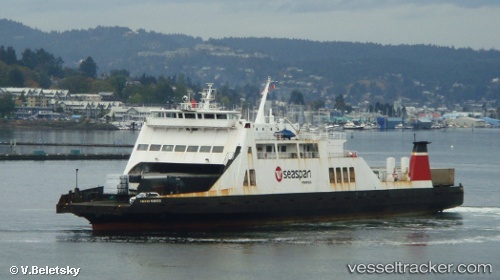
 Carrier Princess
Current Status
Where is the vessel?
Carrier Princess is currently in Near Bowen Island, based on AIS data received about 1d ago.
Latest AIS update:
Current position: 49.28200° N, 123.41945° W (Near Bowen Island)
Average speed (last 7 days): Loading…
Average speed (last 30 days): Loading…
Vessel profile: Carrier Princess is a Ro Ro Cargo Ship with dimensions 112m x 20m.
This page combines live AIS, route history, probable destination signals, nearby traffic, and port activity for practical vessel monitoring.
The current position of vessel Carrier Princess is 49.28200 lat / -123.41945 lng. Updated: 2026-04-24 17:40:39 UTCNearest reference points:
- Near Burrard Inlet
- Near English Bay
- Near Robert's Bank
Currently sailing under the flag of Canada ![]()
Carrier Princess built in 1973 year
Deadweight:
3429 tDetails:
Live Vessel Carrier Princess Analytics (details, animations, etc.)
Recent AIS points (UTC):
2026-04-24 17:40:39 UTC · 49.28200, -123.41945 · SOG 1.4 kn · COG 164°2026-04-24 17:40:39 UTC · 49.28200, -123.41945 · SOG 1.4 kn · COG 164°
2026-04-24 17:40:39 UTC · 49.28200, -123.41945 · SOG 1.4 kn · COG 164°
2026-04-24 17:40:39 UTC · 49.28200, -123.41945 · SOG 1.4 kn · COG 164°