 vesseltracker.com
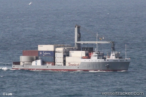
 Tropic Night
Current Status
Where is the vessel?
Tropic Night is currently in 11 nm W of Portsmouth, based on AIS data received about 1h ago.
Latest AIS update:
Current position: 15.49600° N, 61.62900° W (11 nm W of Portsmouth)
Average speed (last 7 days): Loading…
Average speed (last 30 days): Loading…
Vessel profile: Tropic Night is a Landing Craft with dimensions 82m x 18m.
This page combines live AIS, route history, probable destination signals, nearby traffic, and port activity for practical vessel monitoring.
The current position of vessel Tropic Night is 15.49600 lat / -61.62900 lng. Updated: 2026-04-30 12:10:50 UTCNearest reference points:
- Near Le Gosier
- Near Pointe A Pitre
- Near Fort De France
Currently sailing under the flag of St Vincent Grenadines ![]()
Tropic Night built in 1976 year
Deadweight:
2333 tDetails:
Live Vessel Tropic Night Analytics (details, animations, etc.)
Recent AIS points (UTC):
2026-04-30 07:53:31 UTC · 15.99795, -62.01268 · SOG 8.8 kn · COG 129°2026-04-30 10:02:50 UTC · 15.74238, -61.81616 · SOG 8.1 kn · COG 130°
2026-04-30 10:19:00 UTC · 15.71260, -61.79393 · SOG 8 kn · COG 129°
2026-04-30 12:10:50 UTC · 15.49600, -61.62900 · SOG 8.6 kn · COG 118°