 vesseltracker.com
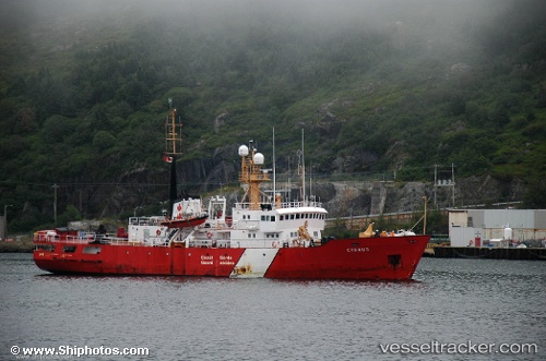
Cygnus
Current StatusWhere is the vessel?
Cygnus is currently in Near St. John’S, based on AIS data received less than 1h ago.
Latest AIS update:
Current position: 47.55651° N, 52.70817° W (Near St. John’S)
Average speed (last 7 days): Loading…
Average speed (last 30 days): Loading…
Vessel profile: Cygnus is a Fishing Support Vessel with dimensions 16m x 68m.
This page combines live AIS, route history, probable destination signals, nearby traffic, and port activity for practical vessel monitoring.
The current position of vessel Cygnus is 47.55651 lat / -52.70817 lng. Updated: 2026-05-16 06:00:34 UTCNearest reference points:
- Near St. John’S
- Near Witless Bay
- Near Catalina
Details:
Live Vessel Cygnus Analytics (details, animations, etc.)
Recent AIS points (UTC):
2026-05-16 01:57:36 UTC · 47.55658, -52.70811 · SOG 0 kn · COG 221°2026-05-16 03:48:36 UTC · 47.55652, -52.70815 · SOG 0 kn · COG 221°
2026-05-16 05:12:34 UTC · 47.55655, -52.70819 · SOG 0 kn · COG 220°
2026-05-16 06:00:34 UTC · 47.55651, -52.70817 · SOG 0 kn · COG 220°