 vesseltracker.com
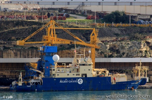
 Peter Faber
Current Status
Where is the vessel?
Peter Faber is currently in Near TAICHUNG, based on AIS data received less than 1h ago.
Latest AIS update:
Current position: 24.26819° N, 120.52414° E (Near TAICHUNG)
Average speed (last 7 days): Loading…
Average speed (last 30 days): Loading…
Vessel profile: Peter Faber is a Cable Layer with dimensions 78m x 14m.
This page combines live AIS, route history, probable destination signals, nearby traffic, and port activity for practical vessel monitoring.
The current position of vessel Peter Faber is 24.26819 lat / 120.52414 lng. Updated: 2026-05-14 11:59:02 UTCNearest reference points:
- Near TAICHUNG
- Near Tai-tung Kang
- Near Miao-li
Currently sailing under the flag of France ![]()
Peter Faber built in 1982 year
Deadweight:
2200 tDetails:
Live Vessel Peter Faber Analytics (details, animations, etc.)
Recent AIS points (UTC):
2026-05-14 07:52:58 UTC · 24.26818, 120.52410 · SOG 0 kn · COG 21°2026-05-14 10:28:57 UTC · 24.26824, 120.52418 · SOG 0 kn · COG 22°
2026-05-14 10:58:58 UTC · 24.26821, 120.52415 · SOG 0 kn · COG 22°
2026-05-14 11:59:02 UTC · 24.26819, 120.52414 · SOG 0 kn · COG 22°