 vesseltracker.com
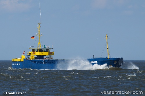
 Amanda
Current Status
Where is the vessel?
Amanda is currently in Near Nowy Port/Gdansk, based on AIS data received less than 1h ago.
Latest AIS update:
Current position: 54.43920° N, 18.64710° E (Near Nowy Port/Gdansk)
Average speed (last 7 days): Loading…
Average speed (last 30 days): Loading…
Vessel profile: Amanda is a General Cargo Ship with dimensions 81m x 11m.
This page combines live AIS, route history, probable destination signals, nearby traffic, and port activity for practical vessel monitoring.
The current position of vessel Amanda is 54.4392 lat / 18.6471 lng. Updated: 2026-04-12 13:25:46 UTCNearest reference points:
- Near Sopot
- Near Nowy Port/Gdansk
- Near Gdynia
Currently sailing under the flag of Denmark ![]()
Amanda built in 1981 year
Deadweight:
1795 tDetails:
Live Vessel Amanda Analytics (details, animations, etc.)
Recent AIS points (UTC):
2026-04-12 08:07:35 UTC · 54.43910, 18.64730 · SOG 0 kn · COG 62°2026-04-12 10:46:41 UTC · 54.43900, 18.64730 · SOG 0 kn · COG 57°
2026-04-12 11:52:43 UTC · 54.43910, 18.64720 · SOG 0 kn · COG 58°
2026-04-12 13:25:46 UTC · 54.43920, 18.64710 · SOG 0 kn · COG 68°