 vesseltracker.com
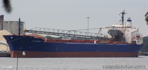
 Bontrup Amsterdam
Current Status
Where is the vessel?
Bontrup Amsterdam is currently in 18 nm SW of Captain Field, based on AIS data received less than 1h ago.
Latest AIS update:
Current position: 58.04548° N, 2.00248° W (18 nm SW of Captain Field)
Average speed (last 7 days): Loading…
Average speed (last 30 days): Loading…
Vessel profile: Bontrup Amsterdam is a Self Discharging Bulk Carrier with dimensions 225m x 32m.
This page combines live AIS, route history, probable destination signals, nearby traffic, and port activity for practical vessel monitoring.
The current position of vessel Bontrup Amsterdam is 58.04548 lat / -2.00248 lng. Updated: 2026-05-15 19:25:54 UTCNearest reference points:
- Near PETERHEAD
- Near Peterhead
- Near Aberdeen
Currently sailing under the flag of Bahamas ![]()
Bontrup Amsterdam built in 1984 year
Deadweight:
59960 tDetails:
Live Vessel Bontrup Amsterdam Analytics (details, animations, etc.)
Recent AIS points (UTC):
2026-05-15 15:58:46 UTC · 57.71182, -1.47783 · SOG 8.1 kn · COG 325°2026-05-15 16:35:45 UTC · 57.77520, -1.57273 · SOG 7.8 kn · COG 324°
2026-05-15 17:33:54 UTC · 57.87333, -1.72833 · SOG 7 kn · COG -1°
2026-05-15 19:25:54 UTC · 58.04548, -2.00248 · SOG 6.9 kn · COG 324°