 Mazu
Mazu
Current Status
Where is the vessel?
Mazu is currently in 24 nm N of Michoacán, based on AIS data received about 14h ago.
Latest AIS update:
Current position: 18.31452° N, 93.82644° W (24 nm N of Michoacán)
Average speed (last 7 days): Loading…
Average speed (last 30 days): Loading…
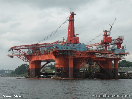
Vessel profile: Mazu is a Offshore Vessel with dimensions 90m x 55m.
This page combines live AIS, route history, probable destination signals, nearby traffic, and port activity for practical vessel monitoring.
The current position of vessel Mazu is 18.31452 lat / -93.82644 lng. Updated: 2026-05-23 18:08:04 UTCNearest reference points:
- Near Coatzacoalcos
- 35 nm S of Yùum K'Ak'Náab
- 18 nm S of Yùum K'Ak'Náab
Currently sailing under the flag of Mexico ![]()
Mazu built in 1983 year
Deadweight:
14793 tDetails:
Live Vessel Mazu Analytics (details, animations, etc.)
Recent AIS points (UTC):
2026-05-23 13:10:07 UTC · 18.31453, -93.82649 · SOG 0 kn · COG -1°2026-05-23 13:52:40 UTC · 18.31453, -93.82646 · SOG 0 kn · COG -1°
2026-05-23 13:52:40 UTC · 18.31453, -93.82646 · SOG 0 kn · COG -1°
2026-05-23 18:08:04 UTC · 18.31452, -93.82644 · SOG 0 kn · COG -1°