 vesseltracker.com
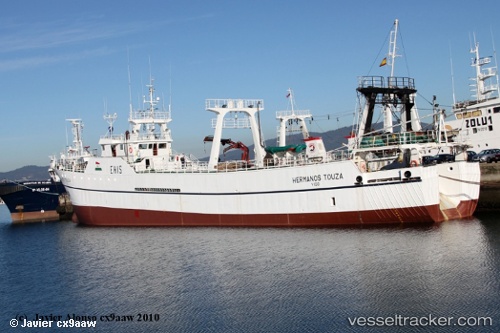
 HERMANOS TOUZA
Current Status
Where is the vessel?
HERMANOS TOUZA is currently in 125 nm NE of Fernando De Noronha, based on AIS data received less than 1h ago.
Latest AIS update:
Current position: 2.64833° S, 30.69333° W (125 nm NE of Fernando De Noronha)
Average speed (last 7 days): Loading…
Average speed (last 30 days): Loading…
Vessel profile: HERMANOS TOUZA is a Fishing Vessel with dimensions 10m x 74m.
This page combines live AIS, route history, probable destination signals, nearby traffic, and port activity for practical vessel monitoring.
The current position of vessel HERMANOS TOUZA is -2.64833 lat / -30.69333 lng. Updated: 2026-05-15 18:20:19 UTCCurrently sailing under the flag of Falkland Islands ![]()
HERMANOS TOUZA built in 1986 year
Deadweight:
943 tDetails:
Live Vessel HERMANOS TOUZA Analytics (details, animations, etc.)
Recent AIS points (UTC):
2026-05-15 13:42:00 UTC · -3.41352, -31.01887 · SOG 10.9 kn · COG 31°2026-05-15 16:11:02 UTC · -3.01032, -30.84728 · SOG 10.7 kn · COG 30°
2026-05-15 16:11:02 UTC · -3.01032, -30.84728 · SOG 10.7 kn · COG 30°
2026-05-15 18:20:19 UTC · -2.64833, -30.69333 · SOG 11 kn · COG -1°