 vesseltracker.com
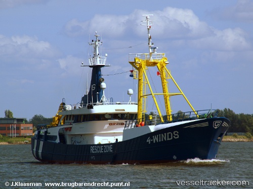
 Glomar 4 WINDS
Current Status
Where is the vessel?
Glomar 4 WINDS is currently in 30 nm W of Neeltje Jans, based on AIS data received less than 1h ago.
Latest AIS update:
Current position: 53.72667° N, 2.87167° E (30 nm W of Neeltje Jans)
Average speed (last 7 days): Loading…
Average speed (last 30 days): Loading…
Vessel profile: Glomar 4 WINDS is a Standby Safety Vessel with dimensions 46m x 9m.
This page combines live AIS, route history, probable destination signals, nearby traffic, and port activity for practical vessel monitoring.
The current position of vessel Glomar 4 WINDS is 53.72667 lat / 2.87167 lng. Updated: 2026-05-16 03:18:14 UTCNearest reference points:
- 19 nm NW of Neeltje Jans
- 48 nm NE of Somersby
- Near Neeltje Jans
Currently sailing under the flag of Panama ![]()
Glomar 4 WINDS built in 1986 year
Details:
Live Vessel Glomar 4 WINDS Analytics (details, animations, etc.)
Recent AIS points (UTC):
2026-05-15 23:27:13 UTC · 53.76667, 2.87167 · SOG 3 kn · COG -1°2026-05-16 00:36:14 UTC · 53.69833, 2.87833 · SOG 3 kn · COG -1°
2026-05-16 01:48:12 UTC · 53.70833, 2.87833 · SOG 3 kn · COG -1°
2026-05-16 03:18:14 UTC · 53.72667, 2.87167 · SOG 3 kn · COG -1°