 vesseltracker.com
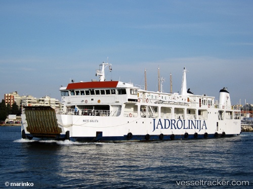
 Mate Balota
Current Status
Where is the vessel?
Mate Balota is currently in Near RAB, based on AIS data received less than 1h ago.
Latest AIS update:
Current position: 44.65862° N, 14.73001° E (Near RAB)
Average speed (last 7 days): Loading…
Average speed (last 30 days): Loading…
Vessel profile: Mate Balota is a Passenger Ro Ro Cargo Ship with dimensions 65m x 13m.
This page combines live AIS, route history, probable destination signals, nearby traffic, and port activity for practical vessel monitoring.
The current position of vessel Mate Balota is 44.65862 lat / 14.73001 lng. Updated: 2026-05-14 11:37:49 UTCNearest reference points:
- Near Veli Losinj
- Near MALI LOSINJ
- Near Ist
Currently sailing under the flag of Croatia ![]()
Mate Balota built in 1988 year
Deadweight:
350 tDetails:
Live Vessel Mate Balota Analytics (details, animations, etc.)
Recent AIS points (UTC):
2026-05-14 08:24:19 UTC · 45.02311, 14.47504 · SOG 8.7 kn · COG -1°2026-05-14 10:13:19 UTC · 44.82390, 14.64182 · SOG 7.3 kn · COG -1°
2026-05-14 10:41:19 UTC · 44.76814, 14.66335 · SOG 7.5 kn · COG -1°
2026-05-14 11:37:49 UTC · 44.65862, 14.73001 · SOG 7.7 kn · COG -1°