 vesseltracker.com
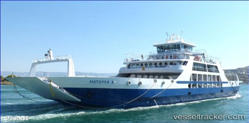
Matoula K
Current StatusWhere is the vessel?
Matoula K is currently in Near Paloúkia, based on AIS data received about 1h ago.
Latest AIS update:
Current position: 37.96023° N, 23.54320° E (Near Paloúkia)
Average speed (last 7 days): Loading…
Average speed (last 30 days): Loading…
Vessel profile: Matoula K is a Passenger Ro Ro Cargo Ship with dimensions 20m x 85m.
This page combines live AIS, route history, probable destination signals, nearby traffic, and port activity for practical vessel monitoring.
The current position of vessel Matoula K is 37.96023 lat / 23.54320 lng. Updated: 2026-05-14 13:53:54 UTCNearest reference points:
- Near PERAMA
- Near Keratsínion
- Near Drapetzona
Details:
Live Vessel Matoula K Analytics (details, animations, etc.)
Recent AIS points (UTC):
2026-05-12 12:13:42 UTC · 37.95983, 23.54471 · SOG 9 kn · COG -1°2026-05-14 12:17:27 UTC · 37.96286, 23.55549 · SOG 5.5 kn · COG -1°
2026-05-14 13:35:28 UTC · 37.96380, 23.55624 · SOG 0 kn · COG -1°
2026-05-14 13:53:54 UTC · 37.96023, 23.54320 · SOG 6.4 kn · COG -1°