 vesseltracker.com
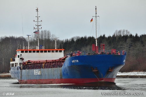
 Burgtor
Current Status
Where is the vessel?
Burgtor is currently in Near Damietta, based on AIS data received less than 1h ago.
Latest AIS update:
Current position: 31.53350° N, 31.73392° E (Near Damietta)
Average speed (last 7 days): Loading…
Average speed (last 30 days): Loading…
Vessel profile: Burgtor is a Multi Purpose Carrier with dimensions 87m x 13m.
This page combines live AIS, route history, probable destination signals, nearby traffic, and port activity for practical vessel monitoring.
The current position of vessel Burgtor is 31.53350 lat / 31.73392 lng. Updated: 2026-05-14 12:16:25 UTCNearest reference points:
- Near Damietta
- 21 nm N of Port Said
- 15 nm N of Port Said
Currently sailing under the flag of Antigua Barbuda ![]()
Burgtor built in 1989 year
Deadweight:
3432 tDetails:
Live Vessel Burgtor Analytics (details, animations, etc.)
Recent AIS points (UTC):
2026-05-14 07:25:32 UTC · 31.53505, 31.73335 · SOG 0.7 kn · COG 223°2026-05-14 09:34:28 UTC · 31.53462, 31.73377 · SOG 0.1 kn · COG 248°
2026-05-14 10:07:34 UTC · 31.53431, 31.73387 · SOG 0.1 kn · COG 263°
2026-05-14 12:16:25 UTC · 31.53350, 31.73392 · SOG 0.1 kn · COG 288°