 vesseltracker.com
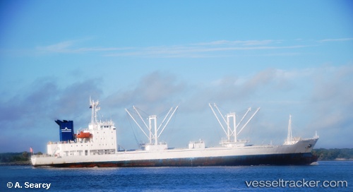
 ATLANTIC ROSE
Current Status
Where is the vessel?
ATLANTIC ROSE is currently in Near Barrosso Terminal, based on AIS data received less than 1h ago.
Latest AIS update:
Current position: 23.89174° S, 45.53022° W (Near Barrosso Terminal)
Average speed (last 7 days): Loading…
Average speed (last 30 days): Loading…
Vessel profile: ATLANTIC ROSE is a Reefer with dimensions m x m.
This page combines live AIS, route history, probable destination signals, nearby traffic, and port activity for practical vessel monitoring.
The current position of vessel ATLANTIC ROSE is -23.89174 lat / -45.53022 lng. Updated: 2026-04-28 22:07:42 UTCNearest reference points:
- Near Barrosso Terminal
- 30 nm SE of Guarujá
- Near Guarujá
Currently sailing under the flag of Saint Kitts and Nevis ![]()
Details:
Live Vessel ATLANTIC ROSE Analytics (details, animations, etc.)
Recent AIS points (UTC):
2026-04-28 17:36:26 UTC · -23.89225, -45.53074 · SOG 2 kn · COG 298°2026-04-28 20:02:59 UTC · -23.89204, -45.53037 · SOG 1 kn · COG 282°
2026-04-28 21:34:42 UTC · -23.89176, -45.53026 · SOG 1.2 kn · COG 269°
2026-04-28 22:07:42 UTC · -23.89174, -45.53022 · SOG 1.2 kn · COG 272°