 vesseltracker.com
 Moor
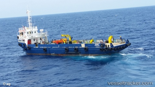
Moor
Current Status
Where is the vessel?
Moor is currently in Near MARSAMXETT, based on AIS data received about 1h ago.
Latest AIS update:
Current position: 35.92406° N, 14.54598° E (Near MARSAMXETT)
Average speed (last 7 days): Loading…
Average speed (last 30 days): Loading…
Vessel profile: Moor is a Research Vessel with dimensions 37m x 10m.
This page combines live AIS, route history, probable destination signals, nearby traffic, and port activity for practical vessel monitoring.
The current position of vessel Moor is 35.92406 lat / 14.54598 lng. Updated: 2026-05-14 20:02:56 UTCNearest reference points:
- Near Xghajra
- Near MARSAMXETT
- Near Birgu (Vittoriosa)
Currently sailing under the flag of Malta ![]()
Moor built in 1982 year
Deadweight:
274 tDetails:
Live Vessel Moor Analytics (details, animations, etc.)
Recent AIS points (UTC):
2026-05-14 16:19:57 UTC · 35.96490, 14.58428 · SOG 0.1 kn · COG 72°2026-05-14 17:23:57 UTC · 35.96218, 14.58274 · SOG 0.6 kn · COG 299°
2026-05-14 19:44:37 UTC · 35.89547, 14.51883 · SOG 7.5 kn · COG 52°
2026-05-14 20:02:56 UTC · 35.92406, 14.54598 · SOG 7.3 kn · COG 35°