 vesseltracker.com
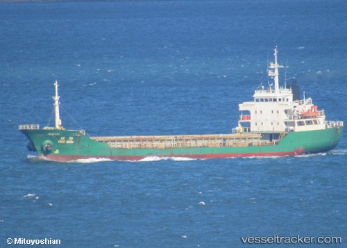
 SILVER WAY
Current Status
Where is the vessel?
SILVER WAY is currently in Near Kawasaki, based on AIS data received less than 1h ago.
Latest AIS update:
Current position: 35.47553° N, 139.75221° E (Near Kawasaki)
Average speed (last 7 days): Loading…
Average speed (last 30 days): Loading…
Vessel profile: SILVER WAY is a General Cargo Ship with dimensions 10m x 93m.
This page combines live AIS, route history, probable destination signals, nearby traffic, and port activity for practical vessel monitoring.
The current position of vessel SILVER WAY is 35.47553 lat / 139.75221 lng. Updated: 2026-05-18 01:42:24 UTCNearest reference points:
- Near Kawasaki
- Near Yokohama
- Near Aomi
Currently sailing under the flag of Sierra leone ![]()
SILVER WAY built in 1991 year
Deadweight:
3501 tDetails:
Live Vessel SILVER WAY Analytics (details, animations, etc.)
Recent AIS points (UTC):
2026-05-17 22:58:45 UTC · 35.48440, 139.77078 · SOG 0 kn · COG 75°2026-05-17 23:43:44 UTC · 35.48423, 139.77081 · SOG 0 kn · COG 65°
2026-05-18 01:41:13 UTC · 35.47485, 139.75485 · SOG 6.8 kn · COG 285°
2026-05-18 01:42:24 UTC · 35.47553, 139.75221 · SOG 6.8 kn · COG 294°