 vesseltracker.com
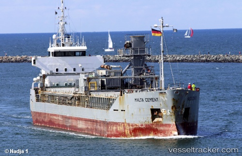
 Malta Cement
Current Status
Where is the vessel?
Malta Cement is currently in Near Las Casas de Alcanar, based on AIS data received about 1h ago.
Latest AIS update:
Current position: 40.56145° N, 0.58176° E (Near Las Casas de Alcanar)
Average speed (last 7 days): Loading…
Average speed (last 30 days): Loading…
Vessel profile: Malta Cement is a Cement Carrier with dimensions 88m x 13m.
This page combines live AIS, route history, probable destination signals, nearby traffic, and port activity for practical vessel monitoring.
The current position of vessel Malta Cement is 40.56145 lat / 0.58176 lng. Updated: 2026-05-15 23:43:24 UTCNearest reference points:
- Near San Carlos de la Rápita
- Near OROPESA DEL MAR
- Near CAMBRILS
Currently sailing under the flag of Netherlands ![]()
Malta Cement built in 1991 year
Deadweight:
3961 tDetails:
Live Vessel Malta Cement Analytics (details, animations, etc.)
Recent AIS points (UTC):
2026-05-15 19:52:24 UTC · 40.56143, 0.58148 · SOG 0 kn · COG 351°2026-05-15 21:43:23 UTC · 40.56140, 0.58139 · SOG 0.1 kn · COG 356°
2026-05-15 22:10:23 UTC · 40.56144, 0.58125 · SOG 0.1 kn · COG 0°
2026-05-15 23:43:24 UTC · 40.56145, 0.58176 · SOG 0.9 kn · COG 321°