 vesseltracker.com
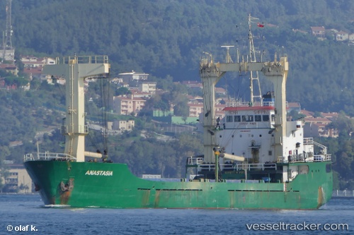
 ANASTASIA
Current Status
Where is the vessel?
ANASTASIA is currently in Near Gebze, based on AIS data received less than 1h ago.
Latest AIS update:
Current position: 40.72583° N, 29.40287° E (Near Gebze)
Average speed (last 7 days): Loading…
Average speed (last 30 days): Loading…
Vessel profile: ANASTASIA is a General Cargo Ship with dimensions 84m x 14m.
This page combines live AIS, route history, probable destination signals, nearby traffic, and port activity for practical vessel monitoring.
The current position of vessel ANASTASIA is 40.72583 lat / 29.40287 lng. Updated: 2026-05-15 11:39:47 UTCNearest reference points:
- Near YALOVA
- Near Tuzla Free Zone
- Near TUZLA
Currently sailing under the flag of Palau (Republic of) ![]()
ANASTASIA built in 1996 year
Deadweight:
4056 tDetails:
Live Vessel ANASTASIA Analytics (details, animations, etc.)
Recent AIS points (UTC):
2026-05-15 07:51:58 UTC · 40.85316, 28.96263 · SOG 3.6 kn · COG 114°2026-05-15 09:40:29 UTC · 40.81027, 29.11765 · SOG 5.4 kn · COG 114°
2026-05-15 10:29:39 UTC · 40.76796, 29.23480 · SOG 7.5 kn · COG 113°
2026-05-15 11:39:47 UTC · 40.72583, 29.40287 · SOG 7.6 kn · COG 73°