 vesseltracker.com
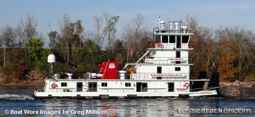
 Cincinnati
Current Status
Where is the vessel?
Cincinnati is currently in Near Texas City, based on AIS data received about 1h ago.
Latest AIS update:
Current position: 29.37748° N, 94.87172° W (Near Texas City)
Average speed (last 7 days): Loading…
Average speed (last 30 days): Loading…
Vessel profile: Cincinnati is a Service Ship with dimensions 209m x 221m.
This page combines live AIS, route history, probable destination signals, nearby traffic, and port activity for practical vessel monitoring.
The current position of vessel Cincinnati is 29.37748 lat / -94.87172 lng. Updated: 2026-04-30 10:28:08 UTCNearest reference points:
- Near Texas City
- Near Port Bolivar
- Near Clear Lake Shores
Currently sailing under the flag of USA ![]()
Details:
Live Vessel Cincinnati Analytics (details, animations, etc.)
Recent AIS points (UTC):
2026-04-30 07:29:18 UTC · 29.37746, -94.87172 · SOG 0 kn · COG -1°2026-04-30 07:43:38 UTC · 29.37747, -94.87172 · SOG 0 kn · COG -1°
2026-04-30 09:29:59 UTC · 29.37746, -94.87170 · SOG 0 kn · COG -1°
2026-04-30 10:28:08 UTC · 29.37748, -94.87172 · SOG 0 kn · COG -1°