 vesseltracker.com
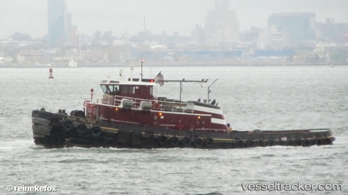
 Ellen Mcallister
Current Status
Where is the vessel?
Ellen Mcallister is currently in Near Bayview, based on AIS data received about 1h ago.
Latest AIS update:
Current position: 41.29375° N, 72.90448° W (Near Bayview)
Average speed (last 7 days): Loading…
Average speed (last 30 days): Loading…
Vessel profile: Ellen Mcallister is a Tug with dimensions 35m x 10m.
This page combines live AIS, route history, probable destination signals, nearby traffic, and port activity for practical vessel monitoring.
The current position of vessel Ellen Mcallister is 41.29375 lat / -72.90448 lng. Updated: 2026-05-14 06:28:15 UTCNearest reference points:
- Near Southport
- Near Purchase
- Near Springville, Suffolk
Currently sailing under the flag of USA ![]()
Details:
Live Vessel Ellen Mcallister Analytics (details, animations, etc.)
Recent AIS points (UTC):
2026-05-14 02:25:37 UTC · 41.29374, -72.90449 · SOG 0 kn · COG -1°2026-05-14 04:11:15 UTC · 41.29371, -72.90450 · SOG 0 kn · COG -1°
2026-05-14 04:25:46 UTC · 41.29373, -72.90448 · SOG 0 kn · COG -1°
2026-05-14 06:28:15 UTC · 41.29375, -72.90448 · SOG 0 kn · COG -1°