 vesseltracker.com
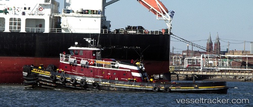
 Beth M Mcallister
Current Status
Where is the vessel?
Beth M Mcallister is currently in Near Puerta de Tierra, based on AIS data received less than 1h ago.
Latest AIS update:
Current position: 18.44769° N, 66.09079° W (Near Puerta de Tierra)
Average speed (last 7 days): Loading…
Average speed (last 30 days): Loading…
Vessel profile: Beth M Mcallister is a Tug with dimensions 33m x 9m.
This page combines live AIS, route history, probable destination signals, nearby traffic, and port activity for practical vessel monitoring.
The current position of vessel Beth M Mcallister is 18.44769 lat / -66.09079 lng. Updated: 2026-04-30 10:02:53 UTCNearest reference points:
- Near San Juan
- Near Roosevelt Roads
- Near Isabel Segunda
Currently sailing under the flag of USA ![]()
Beth M Mcallister built in 1970 year
Deadweight:
345 tDetails:
Live Vessel Beth M Mcallister Analytics (details, animations, etc.)
Recent AIS points (UTC):
2026-04-30 04:21:23 UTC · 18.44770, -66.09082 · SOG 0 kn · COG -1°2026-04-30 07:47:50 UTC · 18.46322, -66.12392 · SOG 2.4 kn · COG -1°
2026-04-30 07:53:50 UTC · 18.46487, -66.12488 · SOG 0.1 kn · COG -1°
2026-04-30 10:02:53 UTC · 18.44769, -66.09079 · SOG 0 kn · COG -1°