 vesseltracker.com
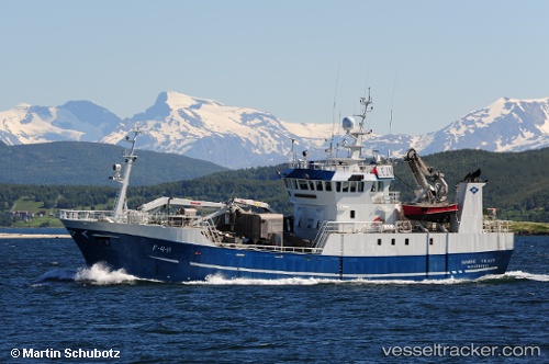
 Bjarne Nilsen
Current Status
Where is the vessel?
Bjarne Nilsen is currently in Near Averøy, based on AIS data received less than 1h ago.
Latest AIS update:
Current position: 63.04631° N, 7.51039° E (Near Averøy)
Average speed (last 7 days): Loading…
Average speed (last 30 days): Loading…
Vessel profile: Bjarne Nilsen is a Fishing Vessel with dimensions 44m x 44m.
This page combines live AIS, route history, probable destination signals, nearby traffic, and port activity for practical vessel monitoring.
The current position of vessel Bjarne Nilsen is 63.04631 lat / 7.51039 lng. Updated: 2026-05-17 20:08:42 UTCNearest reference points:
- Near ELNESVAGEN
- Near Kristiansund
- Near Smøla
Currently sailing under the flag of Norway ![]()
Bjarne Nilsen built in 1992 year
Deadweight:
400 tDetails:
Live Vessel Bjarne Nilsen Analytics (details, animations, etc.)
Recent AIS points (UTC):
2026-05-17 16:15:42 UTC · 63.04630, 7.51040 · SOG 0 kn · COG 248°2026-05-17 18:07:00 UTC · 63.04630, 7.51038 · SOG 0 kn · COG 248°
2026-05-17 19:33:11 UTC · 63.04632, 7.51037 · SOG 0 kn · COG 248°
2026-05-17 20:08:42 UTC · 63.04631, 7.51039 · SOG 0 kn · COG 247°