 vesseltracker.com
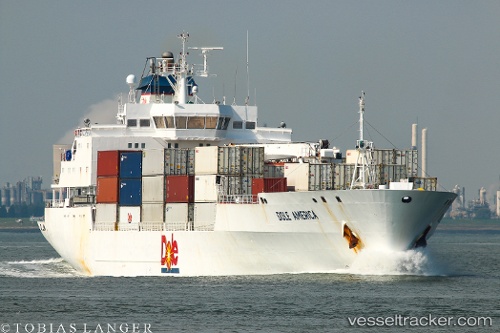
Dole America
Current StatusWhere is the vessel?
Dole America is currently in 22 nm NE of Santa Marta, based on AIS data received less than 1h ago.
Latest AIS update:
Current position: 11.57920° N, 74.04262° W (22 nm NE of Santa Marta)
Average speed (last 7 days): Loading…
Average speed (last 30 days): Loading…
Vessel profile: Dole America is a Refrigerated Cargo Ship with dimensions 22m x 150m.
This page combines live AIS, route history, probable destination signals, nearby traffic, and port activity for practical vessel monitoring.
The current position of vessel Dole America is 11.57920 lat / -74.04262 lng. Updated: 2026-05-14 00:20:24 UTCNearest reference points:
- 18 nm N of Santa Marta
- Near Santa Marta
- Near Contecar
Details:
Live Vessel Dole America Analytics (details, animations, etc.)
Recent AIS points (UTC):
2026-05-13 19:47:58 UTC · 11.79241, -73.78914 · SOG 3.3 kn · COG 219°2026-05-13 21:40:56 UTC · 11.79273, -73.82613 · SOG 1.1 kn · COG 322°
2026-05-13 22:56:22 UTC · 11.79350, -73.85178 · SOG 1.3 kn · COG 323°
2026-05-14 00:20:24 UTC · 11.57920, -74.04262 · SOG 17 kn · COG 219°