 vesseltracker.com
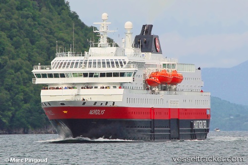
 Nordlys
Current Status
Where is the vessel?
Nordlys is currently in Near Botn - Sandnessjøen, based on AIS data received less than 1h ago.
Latest AIS update:
Current position: 65.96726° N, 12.45477° E (Near Botn - Sandnessjøen)
Average speed (last 7 days): Loading…
Average speed (last 30 days): Loading…
Vessel profile: Nordlys is a Passenger Ro Ro Cargo Ship with dimensions 122m x 20m.
This page combines live AIS, route history, probable destination signals, nearby traffic, and port activity for practical vessel monitoring.
The current position of vessel Nordlys is 65.96726 lat / 12.45477 lng. Updated: 2026-05-13 02:12:50 UTCNearest reference points:
- Near BRONNOYSUND
- Near STRAUMOYVALEN
- Near Vikholmen
Currently sailing under the flag of Norway ![]()
Nordlys built in 1994 year
Deadweight:
850 tDetails:
Live Vessel Nordlys Analytics (details, animations, etc.)
Recent AIS points (UTC):
2026-05-12 22:25:42 UTC · 65.28373, 11.96790 · SOG 14.3 kn · COG 27°2026-05-12 23:28:32 UTC · 65.47478, 12.20772 · SOG 0.5 kn · COG 159°
2026-05-13 01:22:51 UTC · 65.77453, 12.32639 · SOG 15.1 kn · COG 17°
2026-05-13 02:12:50 UTC · 65.96726, 12.45477 · SOG 15 kn · COG 33°