 vesseltracker.com
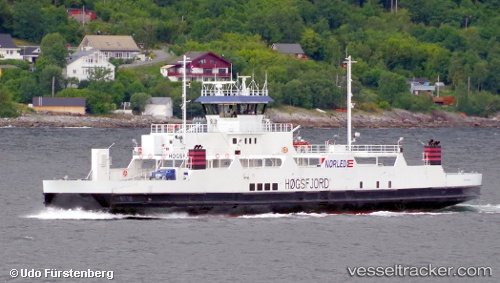
 Hoegsfjord
Current Status
Where is the vessel?
Hoegsfjord is currently in Near Sandnessjøen, based on AIS data received less than 1h ago.
Latest AIS update:
Current position: 65.96922° N, 12.28690° E (Near Sandnessjøen)
Average speed (last 7 days): Loading…
Average speed (last 30 days): Loading…
Vessel profile: Hoegsfjord is a Passenger Ro Ro Cargo Ship with dimensions 82m x 15m.
This page combines live AIS, route history, probable destination signals, nearby traffic, and port activity for practical vessel monitoring.
The current position of vessel Hoegsfjord is 65.96922 lat / 12.28690 lng. Updated: 2026-05-16 12:22:38 UTCNearest reference points:
- Near BRONNOYSUND
- Near STRAUMOYVALEN
- Near Brønnøysund
Currently sailing under the flag of Norway ![]()
Hoegsfjord built in 1992 year
Deadweight:
586 tDetails:
Live Vessel Hoegsfjord Analytics (details, animations, etc.)
Recent AIS points (UTC):
2026-05-16 07:45:27 UTC · 65.96608, 12.29433 · SOG 11.3 kn · COG 136°2026-05-16 09:34:02 UTC · 65.93162, 12.32383 · SOG 0.1 kn · COG 42°
2026-05-16 10:04:09 UTC · 65.92707, 12.43443 · SOG 0 kn · COG 304°
2026-05-16 12:22:38 UTC · 65.96922, 12.28690 · SOG 0 kn · COG 187°