 vesseltracker.com
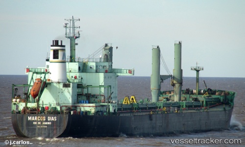
 Marcos Dias
Current Status
Where is the vessel?
Marcos Dias is currently in Near Areia Branca, based on AIS data received about 1h ago.
Latest AIS update:
Current position: 4.82167° S, 37.04333° W (Near Areia Branca)
Average speed (last 7 days): Loading…
Average speed (last 30 days): Loading…
Vessel profile: Marcos Dias is a Bulk Carrier with dimensions 199m x 30m.
This page combines live AIS, route history, probable destination signals, nearby traffic, and port activity for practical vessel monitoring.
The current position of vessel Marcos Dias is -4.82167 lat / -37.04333 lng. Updated: 2026-05-14 07:41:16 UTCNearest reference points:
- 20 nm E of Natal
- 28 nm N of Pecém Pt/São Gonçalo do Amarante
Currently sailing under the flag of Brazil ![]()
Marcos Dias built in 1995 year
Deadweight:
44621 tDetails:
Live Vessel Marcos Dias Analytics (details, animations, etc.)
Recent AIS points (UTC):
2026-05-14 04:05:16 UTC · -4.82167, -37.04333 · SOG 0 kn · COG -1°2026-05-14 06:08:13 UTC · -4.82167, -37.04333 · SOG 0 kn · COG -1°
2026-05-14 07:05:15 UTC · -4.82167, -37.04333 · SOG 0 kn · COG -1°
2026-05-14 07:41:16 UTC · -4.82167, -37.04333 · SOG 0 kn · COG -1°