 vesseltracker.com
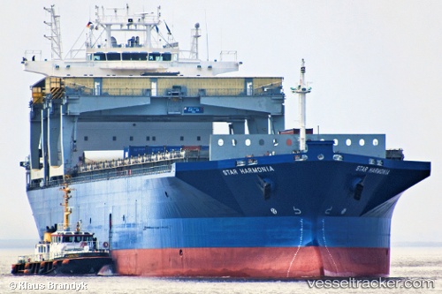
 Star Harmonia
Current Status
Where is the vessel?
Star Harmonia is currently in Near Emmastad, based on AIS data received less than 1h ago.
Latest AIS update:
Current position: 12.12046° N, 68.91416° W (Near Emmastad)
Average speed (last 7 days): Loading…
Average speed (last 30 days): Loading…
Vessel profile: Star Harmonia is a Multi Purpose Carrier with dimensions 198m x 31m.
This page combines live AIS, route history, probable destination signals, nearby traffic, and port activity for practical vessel monitoring.
The current position of vessel Star Harmonia is 12.12046 lat / -68.91416 lng. Updated: 2026-05-15 10:19:03 UTCNearest reference points:
- Near Bullenbaai
- Near Las Piedras
- 24 nm NW of Palm Beach
Currently sailing under the flag of Norway ![]()
Star Harmonia built in 1998 year
Deadweight:
46604 tDetails:
Live Vessel Star Harmonia Analytics (details, animations, etc.)
Recent AIS points (UTC):
2026-05-15 07:37:03 UTC · 12.12046, -68.91413 · SOG 0 kn · COG 245°2026-05-15 07:54:59 UTC · 12.12050, -68.91412 · SOG 0 kn · COG 244°
2026-05-15 09:49:03 UTC · 12.12046, -68.91422 · SOG 0 kn · COG 244°
2026-05-15 10:19:03 UTC · 12.12046, -68.91416 · SOG 0 kn · COG 244°