 vesseltracker.com
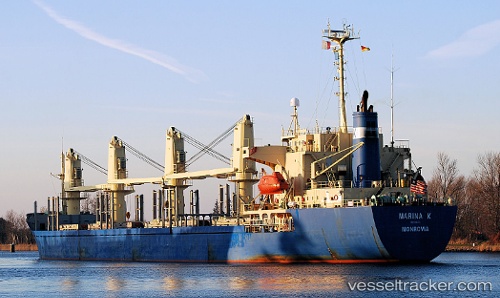
 BOMUSTAFA O
Current Status
Where is the vessel?
BOMUSTAFA O is currently in 15 nm N of Rozi, based on AIS data received less than 1h ago.
Latest AIS update:
Current position: 22.82411° N, 70.04166° E (15 nm N of Rozi)
Average speed (last 7 days): Loading…
Average speed (last 30 days): Loading…
Vessel profile: BOMUSTAFA O is a Bulk Carrier with dimensions 158m x 26m.
This page combines live AIS, route history, probable destination signals, nearby traffic, and port activity for practical vessel monitoring.
The current position of vessel BOMUSTAFA O is 22.82411 lat / 70.04166 lng. Updated: 2026-05-14 04:44:28 UTCNearest reference points:
- 15 nm N of Rozi
- 12 nm N of Rozi
- Near Kandla
Currently sailing under the flag of Panama ![]()
BOMUSTAFA O built in 1995 year
Deadweight:
24173 tDetails:
Live Vessel BOMUSTAFA O Analytics (details, animations, etc.)
Recent AIS points (UTC):
2026-05-14 01:26:28 UTC · 22.82357, 70.04186 · SOG 0.1 kn · COG 269°2026-05-14 01:50:28 UTC · 22.82375, 70.04168 · SOG 0.5 kn · COG 238°
2026-05-14 03:50:28 UTC · 22.82400, 70.04170 · SOG 0 kn · COG 243°
2026-05-14 04:44:28 UTC · 22.82411, 70.04166 · SOG 0 kn · COG 243°