 vesseltracker.com
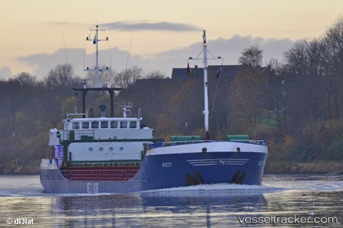
 PAULIN B
Current Status
Where is the vessel?
PAULIN B is currently in Near Botlek, based on AIS data received less than 1h ago.
Latest AIS update:
Current position: 51.90437° N, 4.26618° E (Near Botlek)
Average speed (last 7 days): Loading…
Average speed (last 30 days): Loading…
Vessel profile: PAULIN B is a General Cargo Ship with dimensions 85m x 11m.
This page combines live AIS, route history, probable destination signals, nearby traffic, and port activity for practical vessel monitoring.
The current position of vessel PAULIN B is 51.90437 lat / 4.26618 lng. Updated: 2026-04-19 17:43:47 UTCNearest reference points:
- Near Botlek
- Near Maassluis
- Near BOTLEK - ROTTERDAM
Currently sailing under the flag of Germany ![]()
PAULIN B built in 1995 year
Deadweight:
2335 tDetails:
Live Vessel PAULIN B Analytics (details, animations, etc.)
Recent AIS points (UTC):
2026-04-19 13:57:36 UTC · 51.89085, 3.55796 · SOG 0.1 kn · COG 253°2026-04-19 16:21:34 UTC · 52.00520, 3.95354 · SOG 11.2 kn · COG 110°
2026-04-19 16:42:53 UTC · 51.98889, 4.04345 · SOG 9.1 kn · COG 102°
2026-04-19 17:43:47 UTC · 51.90437, 4.26618 · SOG 9.1 kn · COG 122°