 vesseltracker.com
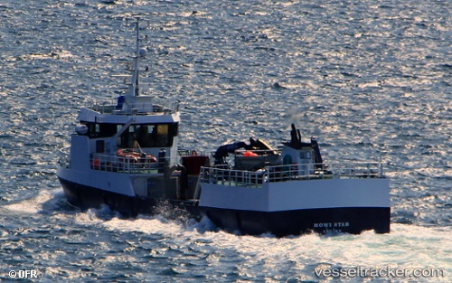
 Mowi Star
Current Status
Where is the vessel?
Mowi Star is currently in Near Austevoll, based on AIS data received less than 1h ago.
Latest AIS update:
Current position: 60.12653° N, 5.06732° E (Near Austevoll)
Average speed (last 7 days): Loading…
Average speed (last 30 days): Loading…
Vessel profile: Mowi Star is a Fish Carrier with dimensions 36m x 8m.
This page combines live AIS, route history, probable destination signals, nearby traffic, and port activity for practical vessel monitoring.
The current position of vessel Mowi Star is 60.12653 lat / 5.06732 lng. Updated: 2026-05-14 05:47:38 UTCNearest reference points:
- Near Glesvær
- Near TORANGSVAG
- Near Hakonsvern
Currently sailing under the flag of Norway ![]()
Mowi Star built in 1996 year
Deadweight:
330 tDetails:
Live Vessel Mowi Star Analytics (details, animations, etc.)
Recent AIS points (UTC):
2026-05-14 01:31:29 UTC · 60.12653, 5.06732 · SOG 0 kn · COG 238°2026-05-14 03:44:28 UTC · 60.12652, 5.06731 · SOG 0 kn · COG 240°
2026-05-14 04:33:28 UTC · 60.12654, 5.06732 · SOG 0 kn · COG 239°
2026-05-14 05:47:38 UTC · 60.12653, 5.06732 · SOG 0 kn · COG 239°