 vesseltracker.com
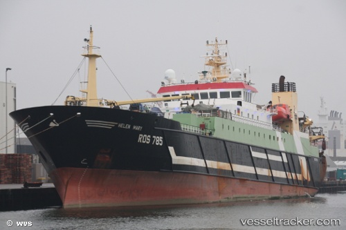
 Ros785 Helen Mary
Current Status
Where is the vessel?
Ros785 Helen Mary is currently in 69 nm W of Foinaven, based on AIS data received less than 1h ago.
Latest AIS update:
Current position: 59.90454° N, 6.53909° W (69 nm W of Foinaven)
Average speed (last 7 days): Loading…
Average speed (last 30 days): Loading…
Vessel profile: Ros785 Helen Mary is a Fishing Vessel with dimensions 117m x 18m.
This page combines live AIS, route history, probable destination signals, nearby traffic, and port activity for practical vessel monitoring.
The current position of vessel Ros785 Helen Mary is 59.90454 lat / -6.53909 lng. Updated: 2026-05-15 16:33:48 UTCNearest reference points:
- 20 nm S of Vágur
- Near Culkein
- Near North Harris
Currently sailing under the flag of Germany ![]()
Ros785 Helen Mary built in 1996 year
Deadweight:
7000 tDetails:
Live Vessel Ros785 Helen Mary Analytics (details, animations, etc.)
Recent AIS points (UTC):
2026-05-15 12:47:54 UTC · 59.79500, -6.37500 · SOG 3 kn · COG -1°2026-05-15 13:38:55 UTC · 59.80667, -6.29167 · SOG 3 kn · COG -1°
2026-05-15 15:56:56 UTC · 59.89333, -6.46333 · SOG 3 kn · COG -1°
2026-05-15 16:33:48 UTC · 59.90454, -6.53909 · SOG 3.9 kn · COG 291°