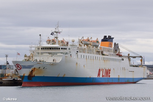
 Biryong
Current Status
Where is the vessel?
Biryong is currently in Near Yeosu, based on AIS data received about 14h ago.
Latest AIS update:
Current position: 34.73342° N, 127.75480° E (Near Yeosu)
Average speed (last 7 days): Loading…
Average speed (last 30 days): Loading…
Vessel profile: Biryong is a Passenger Ro Ro Cargo Ship with dimensions 167m x 22m.
This page combines live AIS, route history, probable destination signals, nearby traffic, and port activity for practical vessel monitoring.
The current position of vessel Biryong is 34.73342 lat / 127.75480 lng. Updated: 2026-05-23 21:37:36 UTCNearest reference points:
- Near Yeosu
- Near Boseong-gun
- Near Sangam-dong
Currently sailing under the flag of Panama ![]()
Biryong built in 1996 year
Deadweight:
3692 tDetails:
Live Vessel Biryong Analytics (details, animations, etc.)
Recent AIS points (UTC):
2026-05-23 17:49:33 UTC · 34.73343, 127.75484 · SOG 0 kn · COG 351°2026-05-23 19:25:35 UTC · 34.73338, 127.75484 · SOG 0 kn · COG 351°
2026-05-23 19:43:35 UTC · 34.73339, 127.75485 · SOG 0 kn · COG 351°
2026-05-23 21:37:36 UTC · 34.73342, 127.75480 · SOG 0 kn · COG 351°