 vesseltracker.com
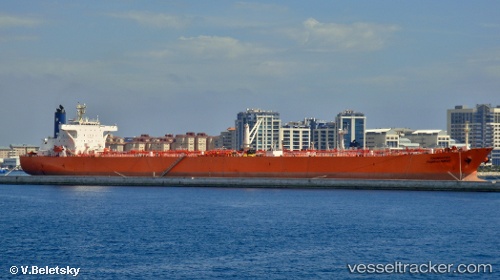
 FOREVER
Current Status
Where is the vessel?
FOREVER is currently in Near Punda, based on AIS data received about 694d ago.
Latest AIS update:
Current position: 12.04784° N, 68.96737° W (Near Punda)
Average speed (last 7 days): Loading…
Average speed (last 30 days): Loading…
Vessel profile: FOREVER is a Crude Oil Tanker with dimensions 247m x 42m.
This page combines live AIS, route history, probable destination signals, nearby traffic, and port activity for practical vessel monitoring.
The current position of vessel FOREVER is 12.04784 lat / -68.96737 lng. Updated: 2024-06-19 08:30:00 UTCNearest reference points:
- Near Bullenbaai
- Near Las Piedras
- 24 nm NW of Palm Beach
Currently sailing under the flag of Gabon ![]()
FOREVER built in 1997 year
Deadweight:
107169 tDetails:
Live Vessel FOREVER Analytics (details, animations, etc.)
Recent AIS points (UTC):
2024-06-19 08:30:00 UTC · 12.04784, -68.96737 · SOG 1.9 kn · COG 26° · DEST WILLEMSTAD