 vesseltracker.com
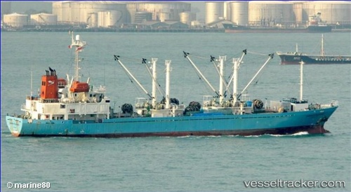
 VOLTA VICTORY
Current Status
Where is the vessel?
VOLTA VICTORY is currently in 19 nm S of SATTAHIP, based on AIS data received about 1h ago.
Latest AIS update:
Current position: 12.33102° N, 100.89585° E (19 nm S of SATTAHIP)
Average speed (last 7 days): Loading…
Average speed (last 30 days): Loading…
Vessel profile: VOLTA VICTORY is a Fish Carrier with dimensions 13m x 91m.
This page combines live AIS, route history, probable destination signals, nearby traffic, and port activity for practical vessel monitoring.
The current position of vessel VOLTA VICTORY is 12.33102 lat / 100.89585 lng. Updated: 2026-05-15 12:44:06 UTCNearest reference points:
- 33 nm S of SATTAHIP
- Near SATTAHIP
- 11 nm S of Map Ta Phut
Currently sailing under the flag of Panama ![]()
VOLTA VICTORY built in 1996 year
Deadweight:
3043 tDetails:
Live Vessel VOLTA VICTORY Analytics (details, animations, etc.)
Recent AIS points (UTC):
2026-05-14 21:38:09 UTC · 12.33138, 100.89581 · SOG 0 kn · COG 269°2026-05-14 21:38:09 UTC · 12.33138, 100.89581 · SOG 0 kn · COG 269°
2026-05-15 12:44:06 UTC · 12.33102, 100.89585 · SOG 0.4 kn · COG 253°
2026-05-15 12:44:06 UTC · 12.33102, 100.89585 · SOG 0.4 kn · COG 253°