 vesseltracker.com
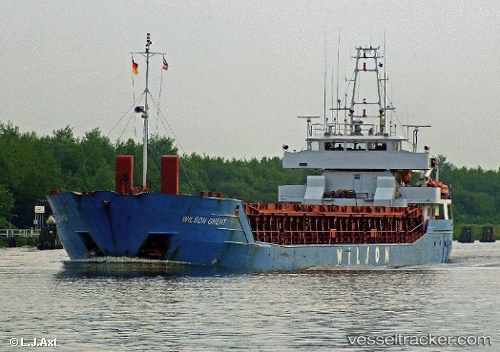
 WILSON GHENT
Current Status
Where is the vessel?
WILSON GHENT is currently in Near Sharpness, based on AIS data received about 1h ago.
Latest AIS update:
Current position: 51.72102° N, 2.47429° W (Near Sharpness)
Average speed (last 7 days): Loading…
Average speed (last 30 days): Loading…
Vessel profile: WILSON GHENT is a General Cargo Ship with dimensions 88m x 13m.
This page combines live AIS, route history, probable destination signals, nearby traffic, and port activity for practical vessel monitoring.
The current position of vessel WILSON GHENT is 51.72102 lat / -2.47429 lng. Updated: 2026-05-01 19:56:48 UTCNearest reference points:
- Near Avonmouth
- Near PORTBURY
- Near Bird Port
Currently sailing under the flag of Barbados ![]()
WILSON GHENT built in 1996 year
Deadweight:
3707 tDetails:
Live Vessel WILSON GHENT Analytics (details, animations, etc.)
Recent AIS points (UTC):
2026-05-01 16:04:42 UTC · 51.72105, -2.47425 · SOG 0 kn · COG 5°2026-05-01 18:25:58 UTC · 51.72103, -2.47430 · SOG 0 kn · COG 4°
2026-05-01 19:10:42 UTC · 51.72103, -2.47431 · SOG 0 kn · COG 4°
2026-05-01 19:56:48 UTC · 51.72102, -2.47429 · SOG 0 kn · COG 4°