 vesseltracker.com
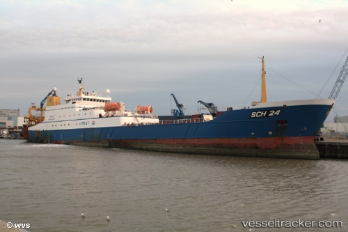
 Sch24 Afrika
Current Status
Where is the vessel?
Sch24 Afrika is currently in 88 nm N of Eisken, based on AIS data received about 1h ago.
Latest AIS update:
Current position: 60.00467° N, 7.33853° W (88 nm N of Eisken)
Average speed (last 7 days): Loading…
Average speed (last 30 days): Loading…
Vessel profile: Sch24 Afrika is a Fishing Vessel with dimensions 126m x 16m.
This page combines live AIS, route history, probable destination signals, nearby traffic, and port activity for practical vessel monitoring.
The current position of vessel Sch24 Afrika is 60.00467 lat / -7.33853 lng. Updated: 2026-05-16 10:09:56 UTCNearest reference points:
- 20 nm S of Vágur
- Near VESTMANNA
- Near North Harris
Currently sailing under the flag of Netherlands ![]()
Sch24 Afrika built in 1999 year
Deadweight:
6400 tDetails:
Live Vessel Sch24 Afrika Analytics (details, animations, etc.)
Recent AIS points (UTC):
2026-05-16 07:17:56 UTC · 60.00529, -7.51455 · SOG 11.9 kn · COG 29°2026-05-16 07:47:57 UTC · 60.10130, -7.47396 · SOG 11.9 kn · COG 16°
2026-05-16 10:03:57 UTC · 60.00474, -7.35346 · SOG 5.2 kn · COG 89°
2026-05-16 10:09:56 UTC · 60.00467, -7.33853 · SOG 4.2 kn · COG 86°