 vesseltracker.com
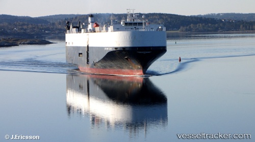
 Chang Rong Kou
Current Status
Where is the vessel?
Chang Rong Kou is currently in 74 nm NE of Kulhudhuffushi Port, based on AIS data received less than 1h ago.
Latest AIS update:
Current position: 7.57667° N, 73.84833° E (74 nm NE of Kulhudhuffushi Port)
Average speed (last 7 days): Loading…
Average speed (last 30 days): Loading…
Vessel profile: Chang Rong Kou is a Vehicles Carrier with dimensions 177m x 31m.
This page combines live AIS, route history, probable destination signals, nearby traffic, and port activity for practical vessel monitoring.
The current position of vessel Chang Rong Kou is 7.57667 lat / 73.84833 lng. Updated: 2026-04-29 04:12:26 UTCNearest reference points:
- 45 nm SW of Kalpeni Island
- Near Cochin
- Near Edappally
Currently sailing under the flag of China ![]()
Chang Rong Kou built in 2000 year
Deadweight:
12778 tDetails:
Live Vessel Chang Rong Kou Analytics (details, animations, etc.)
Recent AIS points (UTC):
2026-04-29 01:36:26 UTC · 7.74833, 73.17167 · SOG 16 kn · COG -1°2026-04-29 01:36:26 UTC · 7.74833, 73.17167 · SOG 16 kn · COG -1°
2026-04-29 03:40:23 UTC · 7.60847, 73.70808 · SOG 16.2 kn · COG 101°
2026-04-29 04:12:26 UTC · 7.57667, 73.84833 · SOG 16 kn · COG -1°