 vesseltracker.com
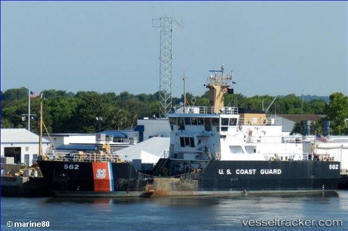
Cg Maria Bray
Current StatusWhere is the vessel?
Cg Maria Bray is currently in Near Mayport, based on AIS data received less than 1h ago.
Latest AIS update:
Current position: 30.38833° N, 81.43333° W (Near Mayport)
Average speed (last 7 days): Loading…
Average speed (last 30 days): Loading…
Vessel profile: Cg Maria Bray is a Buoy Lighthouse Vessel with dimensions 10m x 53m.
This page combines live AIS, route history, probable destination signals, nearby traffic, and port activity for practical vessel monitoring.
The current position of vessel Cg Maria Bray is 30.38833 lat / -81.43333 lng. Updated: 2026-05-13 09:41:18 UTCNearest reference points:
- Near Jacksonville
- Near Ponte Vedra
- Near Fernandina
Details:
Live Vessel Cg Maria Bray Analytics (details, animations, etc.)
Recent AIS points (UTC):
2026-05-13 04:14:18 UTC · 30.38833, -81.43333 · SOG 0 kn · COG -1°2026-05-13 04:53:20 UTC · 30.38833, -81.43333 · SOG 0 kn · COG -1°
2026-05-13 06:29:19 UTC · 30.38833, -81.43333 · SOG 0 kn · COG -1°
2026-05-13 09:41:18 UTC · 30.38833, -81.43333 · SOG 0 kn · COG -1°