 vesseltracker.com
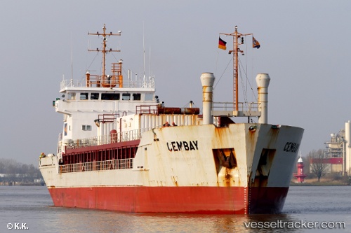
 Cembay
Current Status
Where is the vessel?
Cembay is currently in 28 nm SW of Creac'h-Point, based on AIS data received less than 1h ago.
Latest AIS update:
Current position: 48.08773° N, 5.54396° W (28 nm SW of Creac'h-Point)
Average speed (last 7 days): Loading…
Average speed (last 30 days): Loading…
Vessel profile: Cembay is a Cement Carrier with dimensions 88m x 14m.
This page combines live AIS, route history, probable destination signals, nearby traffic, and port activity for practical vessel monitoring.
The current position of vessel Cembay is 48.08773 lat / -5.54396 lng. Updated: 2026-05-16 10:09:14 UTCNearest reference points:
- 46 nm W of SEIN
- 10 nm S of MOLENE
- Near Creac'h-Point
Currently sailing under the flag of Cyprus ![]()
Cembay built in 1997 year
Deadweight:
4216 tDetails:
Live Vessel Cembay Analytics (details, animations, etc.)
Recent AIS points (UTC):
2026-05-16 07:15:35 UTC · 47.72725, -5.39149 · SOG 8 kn · COG 348°2026-05-16 07:49:14 UTC · 47.79783, -5.42019 · SOG 7.8 kn · COG 348°
2026-05-16 10:05:05 UTC · 48.07817, -5.53987 · SOG 8.3 kn · COG 348°
2026-05-16 10:09:14 UTC · 48.08773, -5.54396 · SOG 8.7 kn · COG 348°