 vesseltracker.com
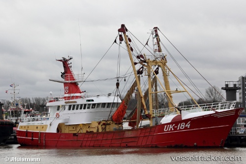
 Uk184 Josephina Mari
Current Status
Where is the vessel?
Uk184 Josephina Mari is currently in Near HARLINGEN, based on AIS data received about 1h ago.
Latest AIS update:
Current position: 53.18112° N, 5.41738° E (Near HARLINGEN)
Average speed (last 7 days): Loading…
Average speed (last 30 days): Loading…
Vessel profile: Uk184 Josephina Mari is a Fishing Vessel with dimensions 42m x 9m.
This page combines live AIS, route history, probable destination signals, nearby traffic, and port activity for practical vessel monitoring.
The current position of vessel Uk184 Josephina Mari is 53.18112 lat / 5.41738 lng. Updated: 2026-05-16 14:07:30 UTCNearest reference points:
- Near HARLINGEN
- Near FRANEKER
- Near Wonseradeel/Makkum
Currently sailing under the flag of Netherlands ![]()
Uk184 Josephina Mari built in 1999 year
Deadweight:
600 tDetails:
Live Vessel Uk184 Josephina Mari Analytics (details, animations, etc.)
Recent AIS points (UTC):
2026-05-16 10:03:11 UTC · 53.18106, 5.41741 · SOG 0 kn · COG 292°2026-05-16 12:23:20 UTC · 53.18098, 5.41747 · SOG 0 kn · COG 293°
2026-05-16 14:01:00 UTC · 53.18102, 5.41738 · SOG 0 kn · COG 292°
2026-05-16 14:07:30 UTC · 53.18112, 5.41738 · SOG 0 kn · COG 291°