 vesseltracker.com
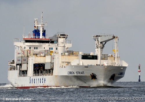
 LOMBOK STRAIT
Current Status
Where is the vessel?
LOMBOK STRAIT is currently in 351 nm SW of Benahavis, based on AIS data received less than 1h ago.
Latest AIS update:
Current position: 32.51373° N, 55.68390° W (351 nm SW of Benahavis)
Average speed (last 7 days): Loading…
Average speed (last 30 days): Loading…
Vessel profile: LOMBOK STRAIT is a Refrigerated Cargo Ship with dimensions 167m x 25m.
This page combines live AIS, route history, probable destination signals, nearby traffic, and port activity for practical vessel monitoring.
The current position of vessel LOMBOK STRAIT is 32.51373 lat / -55.68390 lng. Updated: 2026-05-14 15:38:28 UTCNearest reference points:
- Open sea, approx. 403 nm off the nearest listed port
- Open sea, approx. 402 nm off the nearest listed port
- Open sea, approx. 406 nm off the nearest listed port
Currently sailing under the flag of Liberia ![]()
LOMBOK STRAIT built in 2002 year
Deadweight:
15917 tDetails:
Live Vessel LOMBOK STRAIT Analytics (details, animations, etc.)
Recent AIS points (UTC):
2026-05-14 11:47:23 UTC · 31.73833, -56.86667 · SOG 20 kn · COG -1°2026-05-14 13:24:41 UTC · 32.07222, -56.37599 · SOG 19.9 kn · COG 52°
2026-05-14 13:40:14 UTC · 32.12599, -56.29578 · SOG 20 kn · COG 52°
2026-05-14 15:38:28 UTC · 32.51373, -55.68390 · SOG 19.6 kn · COG 52°