 vesseltracker.com
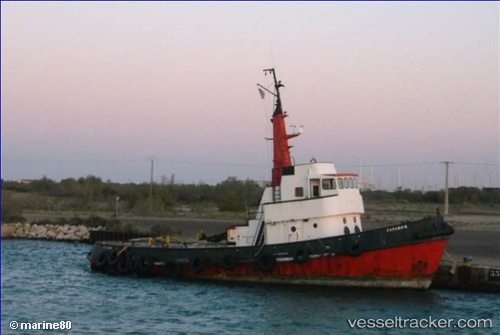
 TANARUS
Current Status
Where is the vessel?
TANARUS is currently in Near TURBO, based on AIS data received about 1h ago.
Latest AIS update:
Current position: 7.94014° N, 76.77128° W (Near TURBO)
Average speed (last 7 days): Loading…
Average speed (last 30 days): Loading…
Vessel profile: TANARUS is a Other Type with dimensions m x m.
This page combines live AIS, route history, probable destination signals, nearby traffic, and port activity for practical vessel monitoring.
The current position of vessel TANARUS is 7.94014 lat / -76.77128 lng. Updated: 2026-05-15 13:48:44 UTCNearest reference points:
- 15 nm NE of Capurgana
- 62 nm NE of Playón Chico
- Near Saboga
Details:
Live Vessel TANARUS Analytics (details, animations, etc.)
Recent AIS points (UTC):
2026-05-15 10:55:05 UTC · 7.94014, -76.77168 · SOG 0 kn · COG -1°2026-05-15 11:27:15 UTC · 7.94014, -76.77169 · SOG 0 kn · COG -1°
2026-05-15 13:46:25 UTC · 7.94014, -76.77129 · SOG 0.3 kn · COG -1°
2026-05-15 13:48:44 UTC · 7.94014, -76.77128 · SOG 0.1 kn · COG -1°